Posts

Showing posts from September, 2019

Monday, September 30th-Mt Rainier National Park

Image
Even though we lived in the Portland area for 10 years, we never visited Mt Rainier NP. Why? Yo no se! Anyway, we spent most of today in the park. We’re camping about 10 miles from one of the entrances in Randle, WA. We’re back in the mountains and it’s really cold again! We follow the weather in Houston and Dallas and we are really sorry you have to put up with that hot weather a little longer. Here’s a pic of the temp here today: We encountered a lot of snow on the ground and a few random flakes in the air! The first hike we went on was the Grove of The Patriarchs trail. Here are a couple of pics of Diana by some of the 1000 year old trees there. For WA these are really big trees!

Sunday, September 29th-Gaelon and Kristi’s Fam!

Image
Today we drove from Forks to Randle, WA. Along the way, we made it a point to go by Gaelon and Kristi Spradley’s and catch up with them. We hadn’t seen them since we moved from Portland more than 10 years ago. Their family has grown by four adorable children- Willa, Cormick, Eloise, and Lucas. They also have bought a new to them home on a lovely acreage just outside of Chehalis. Their new home is the perfect place for kids to grow up! All four of us promised it wouldn’t be 10 years until the next time we get together. Highway 101 follows the WA coast for a while South of Forks and there were some drop-dead gorgeous beaches along the way. Here are a couple of pics of Ruby Beach, WA: Pretty place indeed!

Saturday, September 28th- La Push, WA

Image
La Push is near Forks but over on the WA coast. It’s amazing that Olympia NP covers the central Olympic Peninsula but has a thin gerrymandered strip of land where there are beautiful beaches. I guess Olympic NP is unique that it contains mountains, forests, AND beaches! Anyway, here are a couple of pics of the WA coast of the Pacific: I’ve mentioned before that I’ve wondered where all these driftwood logs came from. WA? CA? OR? Canada? AK? Who knows? But it WOULD be interesting to know, wouldn’t it? We briefly went into Forks again to see the Forks Outfitters (where Bella worked) and I took a pic of Diana with her woodsman friend:

Friday, September 27th-Hoh Rainforest

Image
We spent today at the Hoh Rainforest in Olympic NP. The trails here are different from those in most of the places we’ve been. The most noticeable difference is everything here is lush and green. The rainforest averages about 12 feet or 150 inches of rain a year and, with all that moisture, it certainly stays green! Here’s a pic of the herd of Wapiti deer crossing the road. As you can see there was a “Deerjam! Here are some random pics of places in the park. Whaddaya think? Of all the amazing scenery, two things really stood out: First, here’s the Bride and I near the former root system of a fallen tree: (and, yes, that was a VERY large tree!) The fallen dead tree then becomes a “Nurserylog” as other trees take root and grow from the nutrients in the fallen tree. You can see the trees growing up at the top of the pic. The trees grow along the trunk into what are called colonnades, as shown here: The second amazing thing is that the moss covers almost everything in the

Thursday, September 26th-From Sequim to Forks

Image
After a week in Sequim, it was time to move on so . . . . we moved to Twilightville, WA! Yes, Diana is a fan but I’ve never been able to get into it. Anyway, we stumbled onto Lake Crescent in Olympic NP along the way. The trails around the lake are beautiful, they take you to a small but tall waterfall, the water is a deep turquoise, and we found a beautiful place to have our picnic lunch

Wednesday, September 25th-A Rocktopus?

Today we explored the piers and downtown areas of Port Angeles. Here’s a pic of Diana with her new friend, Rocktopus, at the Olympic Marine Center: (I can’t get the pic to load now so it’ll have to be when we have better coverage)

Tuesday, September 24th-Black Bear Diner and Ya Might Wanna Look at a Map!

Image
We walked about a mile from our campground in Sequim to a Black Bear Diner for breakfast. We’re the taller of the two couples in this pic! Then we headed out to a place you need a map to find: First, find Neah Bay, WA way out West on the Olympic Peninsula. Then keep looking West until you find Cape Flattery. It’s there but you have to look right in the NW corner of WA and the US to find it! Anyway, that’s where we had lunch with the Pacific on our left and the Strait of Juan de Fuca on our eight! It’s literally the NW corner of the contiguous 48 states. We took the half-mile trail to the point and here’s our usual picture having our picnic lunch: The views are beautiful! Here’s the other direction:

Monday, September 23rd-Towels and Tats?

Image
We didn’t do much today except move from one campsite to another because we decided to stay in Sequim a few more days. Our site was reserved so from 27 to 23 we go! I’m not sure I believe all this “Rain shadow” stuff because it rained most of the day here. So takin’ it easy and thinking about Alaska. I remembered two other random noticeable differences between Alaska compared to Canada and the lower 48: First, we saw very few, of any, electric hand dryers in restrooms while we were in Alaska. We get back to BC and AL in Canada and the lower 48 and 80-90% of the hand dryers are electric. Maybe it has something to do with the resources used to make paper towels in Alaska? The second difference we noticed is the percentage of Millennials in Alaska that have one full-arm tattoo. So many of the younger generation in Alaska have converted one of their arms to displaying what is important to them. I’m not the Acme Judgment Company about tats but there are a LOT of tats in Alaska! Just

Sunday, September 22nd-The Dungeness Spit

Image
We drove out to the 4.5 mile Homer Spit in Alaska but you have to walk the 5.5 mile Dungeness Spit.   We didn’t walk to the end because there isn’t even a trail to the end. We walked about 3,000 steps out and that many back. Here are a couple of pics of Diana with some of the driftwood trees that have washed up on the spit: When I see driftwood like this on the shore, I always wonder where it came from. Did it float down from Canada or Alaska, float up from OR or CA, or did it cross the Pacific Ocean and float all the way from Russia, Japan, Korea, etc? BTW, this is a part of the Pacific but it’s actually the Strait of Juan de Fuca. The strait separates the Olympic Peninsula from Vancouver Island, BC, Canada. That’s why you can see Canada and the mountains on Vancouver Island from along the North Coast of the Olympic Peninsula.

Sunday, September 22nd-A BARK Ranger?

Image
We decided that Soo Young needed a bandana from Olympic NP. Whaddya think? This pic is looking straight down on her while this next one is looking at her sitting in her bed. Stylish? Is she stylin’ or what? (Yes, the fireplace is on because it’s 58 degrees here at 2:00 PM!)

Saturday, September 21st-Sequim, Olympic National Park, and the Seattle Seahawks

Image
We got to Sequim (more about this in a minute!), set up the camper, and spent the afternoon in Olympic NP. First, two things about this unique little town on the Strait of Juan de Fuca. 1) the name is pronounced ”Skwim,” NOT “See-Squim.” 2) while the Pacific NW is notes for receiving huge amounts of annual rainfall, Sequim receives only around 20 inches of annual rainfall. Why? Well, it’s been explained to me that Sequim sits in a “rain shadow” of the Olympic Mountains. Wind blows the storms off the Pacific but are blocked when they hit the Olympics. Makes sense to me since the Olympics rise over 9,000 feet from sea level on the Strait! We stopped at a Wally World and saw an example of how fanatical Seattle Seahawks fans are about their team! We drove up to Hurricane Ridge in the park and had a unique experience. It was cloudy but dry in Port Angeles (the largest city on the peninsula) so we thought the visibility would be limited at the top of Hurricane Ridge. Man, were we wrong

Friday, September 20th-More Random Pics

Image

Friday, September 20th-Some Forgotten Photos

Image

Thursday, September 19th-Concern, 12 Deer, and Four Smallish Cities

Image
We’ve been following the weather in Houston and remain concerned about the flooding. It seems that some parts of the Kingwood area are getting flooded even though they didn’t flood during Harvey. If you’re in Houston, stay home and avoid any high water! Today we drove from Mt Vernon on the mainland, on to Fidalgo and Whidbey islands and then took a short ferry trip to Port Townsend. We liked Anacortes, weren’t impressed with Oak Harbor, found Coupeville adorable, and Port Townsend very historic. Not only is Port Townsend full of historic building and Victorian homes, we saw 12 deer in the city limits! Here’s a pic of my Bride by a slice of a 970 year-old tree: The ferry trip from Coupeville to Port Townsend was only 35 minutes so it didn’t compare to the almost two day trip on the Alaska Marine Highway System. Here are Diana, the truck, and camper on the ferry: Here’s a pic on the way here. It’s called Deception Pass: We drove through Fort Worden State Park which was a m

Tuesday, September 17th-North Cascades National Park

Image
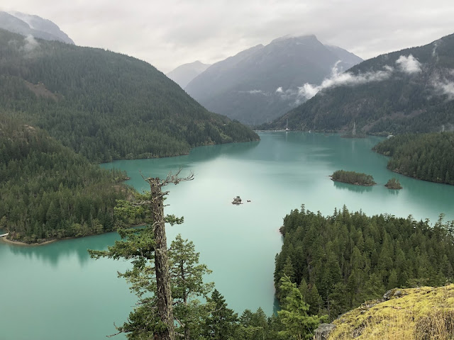
I just got the text that all the Kingwood campuses are closed today. If you’re reading this in or near Houston, BE CAREFUL! Now I just got another text that the entire system is closed tomorrow-be careful down there! We drove from Omak, WA (Try to find that on a map!) to Mt Vernon, WA today. We went through the  heart of North Cascades NP. It’s not an extremely popular park but is still beautiful! Whoda thunk there was a lake with water this color in WA state?

Sunday, September 15th-Omak, WA?

Image
For the next two nights we’re gonna be in this small community. The city has a large park by the Okanogan River with a small RV park in it. It’s treed, quiet, and only $30 a night for full hook ups! Tomorrow is laundry day here and we’ll head for North Cascade NP on Tuesday. Last night we were in the weirdest campground ever. We checked online and we were told there was ONE vacancy. Once we found the place we understood about the one vacancy because this campground has only TWO RV sites for rent! There were no structures of any kind, no signs on the road, and only one other camper in the place. Weird! Here’s a pic of the place:

Saturday, September 14th-Back in the USA. . . Er. . . Lower 48!

Image
After about 2.5 months in Alaska and 3.5 weeks in Canada, we’re back in the lower 48 states. In a way, we were forced back South. Most of the campgrounds in the Canadian Rockies close between the middle of Sept and the first of Oct. Plus British Columbia has a law that fines you if you don’t have snow tires after Oct 1st. Over the next month or so we’ll have more comments about Alaska and Canada but a few are needed here. The differences between Alaska and Canada: Alaska is wild and unrefined. YES, it is more beautiful than other US states in its own way. We saw things there that you can’t experience in any of the other 49 states. We wouldn’t trade anything for our experiences there this summer. We walked up to wild moose, saw the tallest mountain in North America, walked to and on glaciers that are hundreds of feet thick and many miles long, saw pods of whales in the Gulf of Alaska, and cruised down the Inner Passage back to BC. The downsides of AK? It’s understandable that most

Friday, September 13th-The Hot Springs

Image
Today was a take-it-easy day as we laid around in the morning and spent the afternoon at the Radium Hot Springs. The hot springs were there for a long time so it’s logical that the Springs spawned the city of the same name. How hot was it? Well . . . . . 30 degrees Celsius whatever that means! Very soothing and relaxing. There’s not much there to post in the blog except this waterfall and a view of the Columbia River Valley.

Thursday, September 12th-Hiking Day

Image
Today Diana got almost 25,000 steps while I only ended up with 22,000. We hiked from our campground in Kootenay NP to the Radium Hot Springs, back through the canyon to RHS village and the uphill to the campground. Here’s a pic of an RV coming through the canyon just outside of town and the village of Radium Hot Springs. Here’s another pic of the small waterfall that runs alongside the road through the canyon:

Wednesday, September 11th-A Tale of Two Cities...er Lakes!

Image
Not to insult Charles Dickens and his work but today for Slick ‘n Griff was all about two lakes. I’d heard of Lake Louise and, to a lesser extent, Moraine Lake most of my life but Diana and I had never seen them until today. First Lake Louise-this lake is the star of Banff NP, which is the star of Canada’s national parks. Lake Louise is magnificent with mountain peaks and glaciers surrounding it, a picturesque luxury hotel sitting at one end of the lake, and the softest turquoise water you can imagine. Here is a pic: Popular doesn’t begin to define how many people are at LL. This lake is about 1.5 miles long and we had to hike the entire Lakeside Trail to find some solitude. Plus you can’t drive to either lake! We parked at an overflow lot and took a shuttle bus to both lakes. The luxury hotel at Lake Louise is the Fairmont Chateau Lake Louise and is there only for the very well-heeled travelers. It’s location is almost beyond belief. The second lake we visited isn’t as popul